Log in
All resources
Create a design
4,886 Free Images of Map Lichen
bibliothèque nationale de france
a map of the british empire in america with the french and spanish settlements adjacent thereto
maps in the rijksmuseum amsterdam
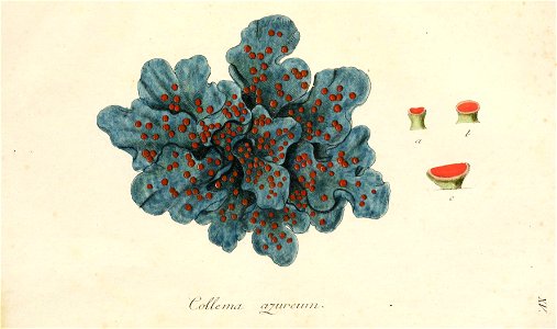
plants
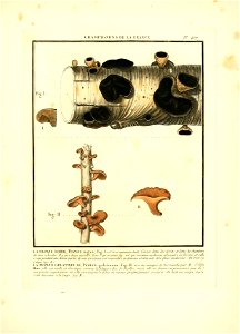
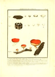
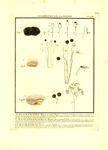
france
fungi
poisonous plant
medicinal plant
pictorial works
new york botanical garden
beschreibung der städt der welt - braun & hogenberg - btv1b52512111k
hierosolyma clarissima totius map by braun & hogenberg
sanson map of the german empire (17th century)
sanson maps of the circles of germany
sanson map of the german empire (17th century)
sanson maps of the circles of germany
atlas géographique des quatre parties du monde (delisle)
map of italy by guillaume delisle (1700)
beschreibung der städt der welt - braun & hogenberg - btv1b52512111k
hierosolyma urbs sancta map by braun & hogenberg
old maps of the london borough of tower hamlets
districts of london
a plan of the operations of the king's army under the command of general sr. william howe, k.b. in new york and east new jersey, against the american forces commanded by general washington, from the 12th. of october, to the 28th. of november 1776
old maps of new york (state) from the norman b. leventhal map center
self-published work
lichen
1529 maps of iran
1529 maps
curt teich postcard archives
postcards of texas
postcards of navajo county, arizona
curt teich postcard archives
john rocque's 1746 map of london
details of old maps of london
juliana of the netherlands in 1969
burgerzaal
arnold van langren map of southwest africa
1596 maps of africa
maps of the ottoman empire by mercator-hondius
eran laor cartographic collection
map of amsterdam by julius milheuser after daniël stalpaert, 1662
maps in the rijksmuseum amsterdam
map of amsterdam by julius milheuser after daniël stalpaert, 1662
maps in the rijksmuseum amsterdam
bern city map of 1638 by matthäus merian
baroque
maps of paris from the university of wisconsin-milwaukee libraries
map of paris by claes jansz. visscher
map of amsterdam by julius milheuser after daniël stalpaert, 1662
maps in the rijksmuseum amsterdam
map of amsterdam by julius milheuser after daniël stalpaert, 1662
maps in the rijksmuseum amsterdam
map of paris by jouvin de rochefort (boutier 112)
historical images of hôtel de ville de paris
map of amsterdam by julius milheuser after daniël stalpaert, 1662
maps in the rijksmuseum amsterdam
america
coral
plants
france
plants
france
plants
france
plants
france
plants
france
british library - off the map alice collection - gardens
collections of the british library
map of the caspian sea by guillaume delisle (1720s)
maps by gerard valck
british library - off the map alice collection - gardens
collections of the british library
british library - off the map alice collection - gardens
collections of the british library
claes jansz. visscher (ii)
1650s maps of the world
maps in the national library of australia
map of paris by claes jansz. visscher
curt teich postcard archives
postcards of miami, oklahoma
map of maastricht by willem and johannes blaeu (1649)
city gates in maastricht
maps of paris from bibliothèque nationale de france
map of paris by claes jansz. visscher
dutch baroque architecture
mans spoor-dijkema
bern city map of 1638 by matthäus merian
baroque
1510s maps of the world
german renaissance
16th-century maps of the middle east
propaganda map
the comprehensive history of england (1876)
english-language maps showing history
maps by thomas kitchin
andrew dury
1600 world map by girolamo porro
1600s maps of the world
paintings by antônio parreiras in the museu antônio parreiras
1910s paintings by antônio parreiras
latin-language maps
bologna ptolemy
map of paris by braun & hogenberg - derivative files
porte papale
old submaps of paris 5e arrondissement
turgot map of paris – derivative files
turgot map of paris – derivative files
proletarian literature
arnold van langren map of southwest africa
1600 maps of africa
map of maastricht by willem and johannes blaeu (1649)
jekerkwartier (maastricht)
atlas géographique des quatre parties du monde (delisle)
map of scandinavia by guillaume de l'isle (1706)
atlas géographique des quatre parties du monde (delisle)
map of scandinavia by guillaume de l'isle (1706)
maps in the rijksmuseum amsterdam
johannes de broen
map of maastricht by willem and johannes blaeu (1649)
first medieval city wall of maastricht
map of amsterdam by gerrit de broen (ii)
maps in the rijksmuseum amsterdam
map of amsterdam by gerrit de broen (ii)
maps in the rijksmuseum amsterdam
works after map of amsterdam, 1544
maps in the rijksmuseum amsterdam
map of amsterdam by gerrit de broen (ii)
maps in the rijksmuseum amsterdam
turgot map of paris, kyoto university library – derivative files
hôtel de guénégaud (quai de nevers)
map of amsterdam by gerrit de broen (ii)
frederik willem greebe
map of amsterdam by gerrit de broen (ii)
maps in the rijksmuseum amsterdam
maps of the ottoman empire by mercator-hondius
eran laor cartographic collection
hierosolyma clarissima totius map by braun & hogenberg
latin-language maps showing history
1596 engravings
renaissance
eran laor cartographic collection
ptolemy's 4th asian map
map of paris by braun & hogenberg - derivative files
porte barbette
map of vienna by jacob hoefnagel
roter turm, vienna
brazilian paintings in the museu antônio parreiras
antônio rafael pinto bandeira
historical images of graben (vienna)
map of vienna by jacob hoefnagel
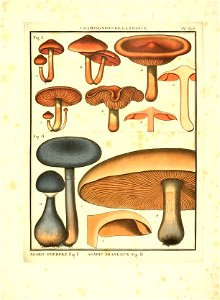
mushrooms
plants
old maps of arkansas in the american civil war
julius bien
map of the upper rhenian circle by sanson
1670s maps of hesse
map of the upper rhenian circle by sanson
1680s maps of north rhine-westphalia
map of the upper rhenian circle by sanson
1700s maps of north rhine-westphalia
nicolas sanson. “mappe-monde, ou carte generale du monde.”
map of the bosphorus strait by guillaume sanson (1665)
grigory anikiyevich kachalov
mikhail makhaev
hoogheemraadschap rijnland map, 2nd edition, 1687
old maps of haarlem
map of maastricht by willem and johannes blaeu (1649)
first medieval city wall of maastricht
prints by romeyn de hooghe
1689 map of haarlem
early netherlandish painting
t and o map
a map of the british empire in america with the french and spanish settlements adjacent thereto
bibliothèque nationale de france
a map of the british empire in america with the french and spanish settlements adjacent thereto
bibliothèque nationale de france
a map of the british empire in america with the french and spanish settlements adjacent thereto
bibliothèque nationale de france
a map of the british empire in america with the french and spanish settlements adjacent thereto
bibliothèque nationale de france
a map of the british empire in america with the french and spanish settlements adjacent thereto
bibliothèque nationale de france
a map of the british empire in america with the french and spanish settlements adjacent thereto
bibliothèque nationale de france
a map of the british empire in america with the french and spanish settlements adjacent thereto
bibliothèque nationale de france
a map of the british empire in america with the french and spanish settlements adjacent thereto
bibliothèque nationale de france
a map of the british empire in america with the french and spanish settlements adjacent thereto
bibliothèque nationale de france
a map of the british empire in america with the french and spanish settlements adjacent thereto
bibliothèque nationale de france
a map of the british empire in america with the french and spanish settlements adjacent thereto
bibliothèque nationale de france
a map of the british empire in america with the french and spanish settlements adjacent thereto
bibliothèque nationale de france
a map of the british empire in america with the french and spanish settlements adjacent thereto
bibliothèque nationale de france
a map of the british empire in america with the french and spanish settlements adjacent thereto
bibliothèque nationale de france
a map of the british empire in america with the french and spanish settlements adjacent thereto
bibliothèque nationale de france
a map of the british empire in america with the french and spanish settlements adjacent thereto
bibliothèque nationale de france
a map of the british empire in america with the french and spanish settlements adjacent thereto
bibliothèque nationale de france
a map of the british empire in america with the french and spanish settlements adjacent thereto
bibliothèque nationale de france
2701 - 2800 of 4,886
Next page
/ 49